
Many thanks for the kind words – really glad you’ve been enjoying the maps. I will definitely take a crack at some 6-mile ocean maps. For the Pacific I may have to tinker a bit to avoid projection issues. Making sure small islands show up may take some finagling but I’ll see what I can do!
Amazing! Thank you very much! If it's alright, can they be in your original colored hex style like the rest of the 6-mile earth maps for consistency sake?
On an only slightly related note I was wondering to myself (and now this does seem like a completely separate task) but with hypsographical data it might be possible to create a map of the ocean with the colour of each hex corresponding to the maximum depth of the water column.
Something like 5 shades of blue, getting progressively darker as the maximum depth shifts from neretic (200m), twilight (1000m), midnight (4000m), abyssal (6000m), and hadal (11000m). It would be amazing and useful for aquatic rpgs to see the continental shelf, the drop-off, the abyssal plain, undersea mountain ranges, seamounts, abyssal trenches and the like.
I don't know if you have space on your backburner for such a task, but I do know that https://www.gebco.net/ have very accurate open-source bathymetric data available!
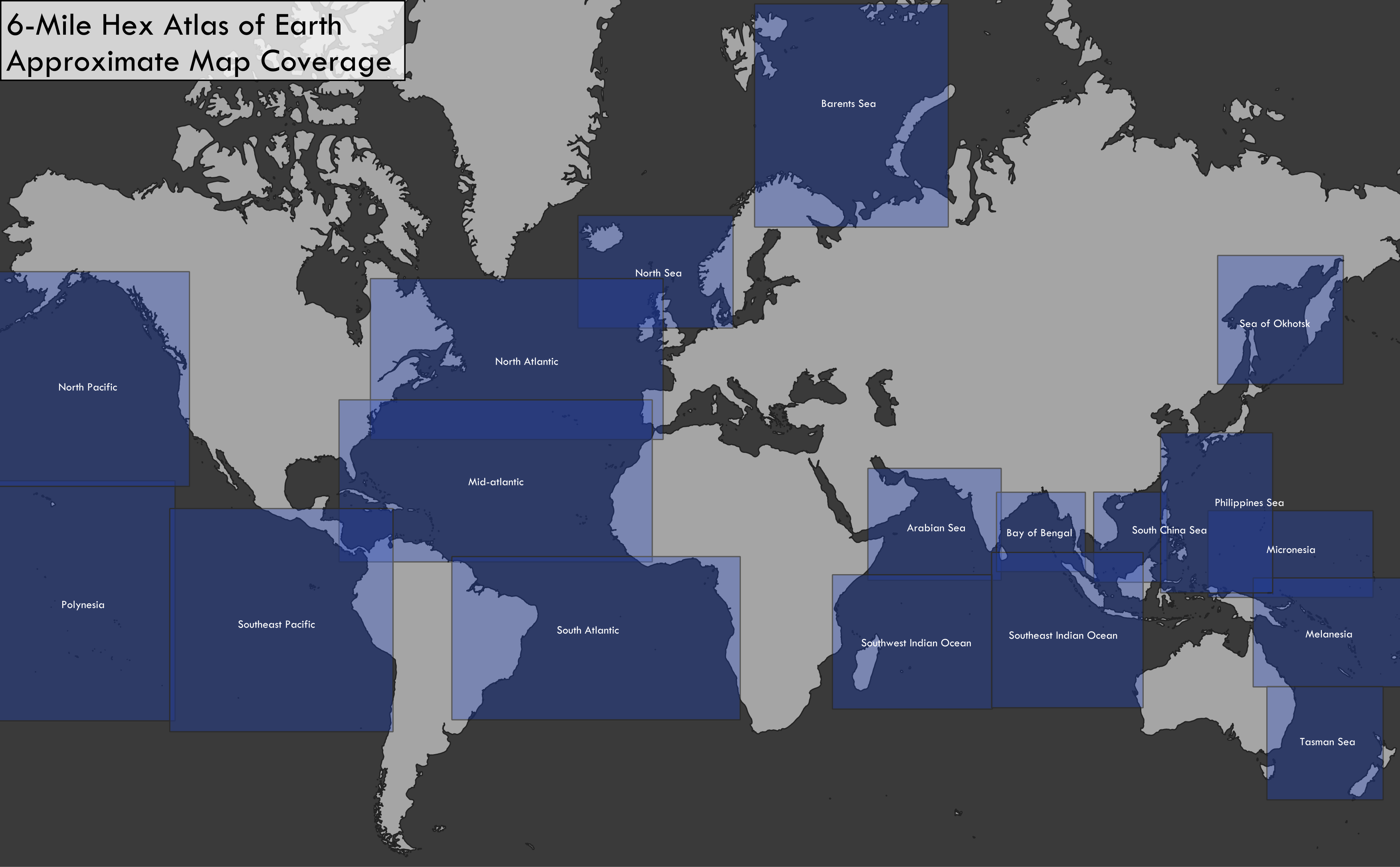
The 6-mile folder has been updated with some ocean maps – hopefully an adequate starting point for your age of sail campaign. You’ll definitely need to double-check that the desired islands are present & probably should manually label some of the smaller atolls in the Pacific. I also wasn’t sure of your desired scope, but I set up the map coverage for minimal overlap so that one could move off one map and onto the next without too much fudging of distances.
Color-coding hexes by water depth is definitely doable, though building it into this script would take some effort. I find that for maps like these they complicate the visualization a bit since color is already used to denote biome on land, but I definitely see the utility (and arguably depth is loosely analogous to biome in aquatic environments). Will definitely add it to my low-priority to-do list.
282 days ago(+1)
Outstanding! I did not expect a result so quickly! These are excellent, supplemented with your originals for key areas like Cape Horn or the Cape of Good Hope this has coverage of essentially every sailed area in that period. Thank you so much!
I agree that blue shading could make the maps look messy. However, with the right subtly of shading I think it could work to convey the difference of depth without look too drastic.