1) What does 'almanac' in the app mean? Like there is an option to remove it from Almanac.
2) Is it possible to undo a change? I tried out changing vantage and it ended up moving some POI and location names to different areas, eg. from a forest to the mountains etc. No way to revert back. Same with messing around with other settings like style, it causes the names to be rerolled. Which sounds like a bug more than a feature.
3) When you use the Permalink option, why does the POI names change when it is viewed on the browser? Is there a way to stop that?
4) It would be nice if we could save ones we like, so we can further tweak them in the future.
Almanac is a list of labelled map features. If you don't want a specific city (wood, mountain range etc) to have a label on the map, "remove it from the almanac". In the same way you can add a map feature to the almanac.
Toponyms are unreliable, sometime they get rerolled when they shouldn't it. It's a bug, but at the moment it is as it is. Changing the Style settings do not get toponyms rerolled though.
Same as the previous point.
Saving any custom changes (custom names, added settlements etc) is a more complex task than it may seem. I don't think this will be implemented anytime soon, but I do hope to fix permalinks.
Love this so much, amazing amazing work. However, I have a suggestion: it would be awesome to individually edit each generated "biome". For example, what I am trying to do is create a summer and winter map, so I'd like to change a "light" forest (deciduous) to "dead" for a winter map, but keep the "dark" forest (evergreen/pine) as is. Or, delete/add individual elements.
I thought I'd let you know that this generator is PERFECT for adding more depth to the very simple story-telling RPG games I play with my 6yr old daughter. Earlier in the year we discovered Amazing Tales, which to a non-TTRPG player like myself, was a simple guide on how to make up a great story and game interactively with your kid. Like any game, sometimes they want a little more, and that's where Perilous Shores and the Village Generator come in. In the narrative, I had us go off to an offshore island (that was on a handdrawn map we had been using), then pulled out a printed copy of an island I'd generated using this. She loved it, in fact I had to print another copy for her to colour in as we played. The villages I'd all generated & printed too, and we added details to them by hand. It's fantastic.
I'm having a lot of trouble with "orphan" road segments I can't get rid of: little loops of road that extend off the map at both ends and don't seem to be linked to any town. Known issue?
This is the lower-left corner of a map, so both of these road segments are looping off-map. I can reproduce the issue pretty consistently by deleting most of the settlements from a large map. The roads get regenerated every time I add or remove a settlement, but once these orphan segments appear it's hard to make them go away entirely.
I have no plans to implement "dynamic" generation (for some reason, people ask about this a lot) - there are too many features that are incompatible with the idea. Not in this generator anyway.
And no plans for an API - this is a fully client-side application, so implementing anything resembling an API would be very awkward.
I appreciate the work and effort that you have put into this amazing resource. I was wondering if there is a way to modify the names of different items in the generator. If so, that would be incredible, if not, I understand. Thank you so much for your time and continued support of this amazing product.
As @Mussia said, you can rename any map feature or the whole map via the context menu. It is also possible to "reroll" all the names at once (Labels > Reroll names).
Thanks a lot. Everything you do rocks. I played Pixel Dungeon for years! The last 2 years i started playing rpg with my family on a region i made with this generator and the dungeon one. Its awesome! You are awesome! Thanks for everything!
I love using this but one issue I have is that if I create a map, bookmark it and then come back to make a tweak after a dev update the map is changed.
I would love to be able to download the generator so I can work with one version over time and avoid the above problem.
From time to time, I build desktop versions (for Windows and macOS) of my most popular generators for my patrons. The last time I did this about a month ago. Unfortunately, using the same version doesn't guarantee that a map will be restored from its permalink exactly the same (at least for some of the generators). I know it undermines the whole idea - it's a bug to be fixed.
I noticed this recently, It seems to move a very little bit east at least in my case over the few months that I have been observing it. I have in the past wondered if there could be a way to pan the map or increase the view range. In any case, I do love all of these generators from the bottom of my heart.
Hi watabou, I love your generators, and Perilous Shores is one of my favorites. You've got the composition dialed in so well, they look great (better than what I do by hand, honestly, which hurts a little). I use PS when I need a new map for a region.
I've started a project where I've got a good sense of what the land shape looks like, but I want to be able to use PS to fill in the detail (mine tend to be too busy). Is there any chance you could add a 'rotation' option, so the user can rotate the output (90 degree increments or by an arbitrary amount) and redraw so the icons and labels are still okay? I've tried doing it by hand and there's a lot of adjustment needed, but I have the sense that 'figuring out landscape' and 'placing and rendering icons' are two distinct stages and might be able to handle it more gracefully than I can manually.
... it just occurred to me, perhaps a 'mirror'/'flip' would be good too. I just realized it's entirely possible everything is exactly right, _but_ the ocean is supposed to be to the west rather than the east.
yep, I'm sure, just confirmed. [] work as expected, but 90 CW and 90 CCW in the context menu do the same thing (rotate 90 CW). Survivable, of course; two wrongs don't make a right but three lefts do. I would guess the same action is assigned to both menu items.
Hello, really a great job here! (As well as the other generators!) Just a question on the level of customization: if I made up a setting with some rules for the generation of an area, would it be possible to see in the next future this generator with these options customizable? I am ref mainly on the population density and the villages number and distance... thanks a lot and keep on improving these wonderful tools!!!
You can customize your region in the "Region parameters" dialog ("Parameters..." in the context menu). The number of settlements is affected by two tags - "civilized" and "barren".
Thanks a lot! I am playing with it and I find very useful a mini-guide which explains all the keywords you can enable within "Parameters": I would be happy to write it however I'd need your support! If you're intetested in it, can we catch up somewhere for a short conversation? Either email or telegram or anything esle... Thanks!
Thanks for your suggestion, but to be honest I don't think there is really a need for a guide here. You can get explanations by shift-clicking tags and while this feature could be more discoverable and wording is often awkward, overall it kind of works. Cheers!
EDIT: there was a problem with my browser settings! Now the feature works, so pls do not consider anymore this post, sorry and thanks!
That would be fine, the real point is that shift+click (as suggested within the parameter window) doesn't work and I am not able to see any explanation. I use a Chrome browser with win10 (correctly updated). Pls let me know, thanks again
Is it possible to combine this beautiful generator with Azgaars Fantasy Map generator - as it is possible to combine the city generator? It would be great to create detailed maps from Azgaars here - also ok if it would be possible to "paint" the region here to make it fit to the existing map from Azgaar. A random region will quite sure not fit to something existing there :-(
Or is it maybe planned that an import of a svg file is possible?
I never considered this (and never discussed with Azgaar), because I think the scopes of these two generators overlap too much. Yes, FMG produces whole worlds and PS generates "regions", but they both deal with dot-like cities, thread-like roads and rivers etc. However, I understand the appeal of idea. At the moment this seems too complicated to implement, but I'll think about it.
No changes made to a map are saved in its permalink and currently there are no plans to fix this (it's an intended behaviour). I'm going to implement embedded tooltips in maps exported as SVG, so this would sort of kind of replicate the way they look within the generator, but it still won't be possible to return to your changes and continue adding them.
To change the name of a region, right-click it and choose "Rename..." in the context menu.
You can request more/less mountains, forests etc. using various tags in the Parameters dialog. At the moment, I'm not planning to implement any ways to specify where those features should be.
Not sure if that's what you're asking about, but you can ctrl+click (or cmd+click on mac) any feature on a map to display "stickers" for all the features (like on this image).
This is so magnificent!!! One request - could you stockpile JSON files with different color schemes. The maps really pop when you tweak the color in different ways!
← Return to generator
Comments
Log in with itch.io to leave a comment.
1) What does 'almanac' in the app mean? Like there is an option to remove it from Almanac.
2) Is it possible to undo a change? I tried out changing vantage and it ended up moving some POI and location names to different areas, eg. from a forest to the mountains etc. No way to revert back. Same with messing around with other settings like style, it causes the names to be rerolled. Which sounds like a bug more than a feature.
3) When you use the Permalink option, why does the POI names change when it is viewed on the browser? Is there a way to stop that?
4) It would be nice if we could save ones we like, so we can further tweak them in the future.
Love it so much. The possibilities to set colors and styles are awesome. Great work watabou!
Love this so much, amazing amazing work. However, I have a suggestion: it would be awesome to individually edit each generated "biome". For example, what I am trying to do is create a summer and winter map, so I'd like to change a "light" forest (deciduous) to "dead" for a winter map, but keep the "dark" forest (evergreen/pine) as is. Or, delete/add individual elements.
It shouldn't be too hard to implement the ability to edit the type of a forest, I'll consider it👍
Love your work @watabou.
Do you think is there any way where we can export this as HTML or other web-friendly formats? Thanks.
But SVG *is* the most web-friendly graphic format there is...
I thought I'd let you know that this generator is PERFECT for adding more depth to the very simple story-telling RPG games I play with my 6yr old daughter. Earlier in the year we discovered Amazing Tales, which to a non-TTRPG player like myself, was a simple guide on how to make up a great story and game interactively with your kid. Like any game, sometimes they want a little more, and that's where Perilous Shores and the Village Generator come in. In the narrative, I had us go off to an offshore island (that was on a handdrawn map we had been using), then pulled out a printed copy of an island I'd generated using this. She loved it, in fact I had to print another copy for her to colour in as we played. The villages I'd all generated & printed too, and we added details to them by hand. It's fantastic.
Cheers!
I'm having a lot of trouble with "orphan" road segments I can't get rid of: little loops of road that extend off the map at both ends and don't seem to be linked to any town. Known issue?
Nope, not a known issue. Could you make a screenshot of this?
This is the lower-left corner of a map, so both of these road segments are looping off-map. I can reproduce the issue pretty consistently by deleting most of the settlements from a large map. The roads get regenerated every time I add or remove a settlement, but once these orphan segments appear it's hard to make them go away entirely.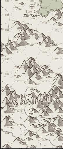
Interesting. I'll try to reproduce it the way you described it and fix this.
I just found it, and instantly felt in love with this. Awesome!
Do you plan to have a dynamic version of it ? Like the starting point is revealed and the world is more open, so you can extend it more and more ?
Also maybe an API ?
I am making a game (experimental project) where the heroes could navigate on the map / dungeon and would be awesome to use this generation on the UI.
~Bug: The shadows option is crashing your app.~
Upd: It is not the shadow option which is bugged, if you do many changes it crashes, I guess memory leak somewhere
Thank you!
I appreciate the work and effort that you have put into this amazing resource. I was wondering if there is a way to modify the names of different items in the generator. If so, that would be incredible, if not, I understand. Thank you so much for your time and continued support of this amazing product.
If you right-click on the name of something, there is an option to edit the name.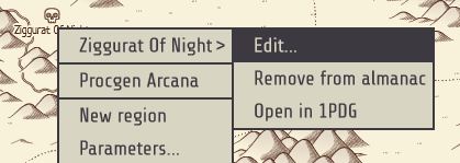
Thank you so much for the reply, I will definitely keep that in mind. :)
As @Mussia said, you can rename any map feature or the whole map via the context menu. It is also possible to "reroll" all the names at once (Labels > Reroll names).
Thank you. I will keep that in mind. :)
Thanks a lot. Everything you do rocks. I played Pixel Dungeon for years! The last 2 years i started playing rpg with my family on a region i made with this generator and the dungeon one. Its awesome! You are awesome! Thanks for everything!
Cheers!
Hi!
I love using this but one issue I have is that if I create a map, bookmark it and then come back to make a tweak after a dev update the map is changed.
I would love to be able to download the generator so I can work with one version over time and avoid the above problem.
Keep up the awesome work.
From time to time, I build desktop versions (for Windows and macOS) of my most popular generators for my patrons. The last time I did this about a month ago. Unfortunately, using the same version doesn't guarantee that a map will be restored from its permalink exactly the same (at least for some of the generators). I know it undermines the whole idea - it's a bug to be fixed.
Okay cool, thanks for that
I noticed this recently, It seems to move a very little bit east at least in my case over the few months that I have been observing it. I have in the past wondered if there could be a way to pan the map or increase the view range. In any case, I do love all of these generators from the bottom of my heart.
I love it!
Suggestion: continue map option - which creates another map continuous with the previously generated map. Great work (obviously :)!)
love this idea! Could do a whole world!
Hi watabou, I love your generators, and Perilous Shores is one of my favorites. You've got the composition dialed in so well, they look great (better than what I do by hand, honestly, which hurts a little). I use PS when I need a new map for a region.
I've started a project where I've got a good sense of what the land shape looks like, but I want to be able to use PS to fill in the detail (mine tend to be too busy). Is there any chance you could add a 'rotation' option, so the user can rotate the output (90 degree increments or by an arbitrary amount) and redraw so the icons and labels are still okay? I've tried doing it by hand and there's a lot of adjustment needed, but I have the sense that 'figuring out landscape' and 'placing and rendering icons' are two distinct stages and might be able to handle it more gracefully than I can manually.
Rotating 90/180/270 degrees shouldn't be a problem, I will add this to my list.
Sweet! Thanks watabou!
... it just occurred to me, perhaps a 'mirror'/'flip' would be good too. I just realized it's entirely possible everything is exactly right, _but_ the ocean is supposed to be to the west rather than the east.
I think I found a bug, though. It seems the 90-degree CCW rotation still rotates CW
Are you sure? It works correctly for me (try the [ and ] keys).
yep, I'm sure, just confirmed. [] work as expected, but 90 CW and 90 CCW in the context menu do the same thing (rotate 90 CW). Survivable, of course; two wrongs don't make a right but three lefts do. I would guess the same action is assigned to both menu items.
Oh, that is slick. Thanks again watabou!
Hello, really a great job here! (As well as the other generators!) Just a question on the level of customization: if I made up a setting with some rules for the generation of an area, would it be possible to see in the next future this generator with these options customizable? I am ref mainly on the population density and the villages number and distance... thanks a lot and keep on improving these wonderful tools!!!
You can customize your region in the "Region parameters" dialog ("Parameters..." in the context menu). The number of settlements is affected by two tags - "civilized" and "barren".
Thanks a lot! I am playing with it and I find very useful a mini-guide which explains all the keywords you can enable within "Parameters": I would be happy to write it however I'd need your support! If you're intetested in it, can we catch up somewhere for a short conversation? Either email or telegram or anything esle... Thanks!
Thanks for your suggestion, but to be honest I don't think there is really a need for a guide here. You can get explanations by shift-clicking tags and while this feature could be more discoverable and wording is often awkward, overall it kind of works. Cheers!
EDIT: there was a problem with my browser settings! Now the feature works, so pls do not consider anymore this post, sorry and thanks!
That would be fine, the real point is that shift+click (as suggested within the parameter window) doesn't work and I am not able to see any explanation. I use a Chrome browser with win10 (correctly updated). Pls let me know, thanks again
Is it possible to combine this beautiful generator with Azgaars Fantasy Map generator - as it is possible to combine the city generator?
It would be great to create detailed maps from Azgaars here - also ok if it would be possible to "paint" the region here to make it fit to the existing map from Azgaar. A random region will quite sure not fit to something existing there :-(
Or is it maybe planned that an import of a svg file is possible?
I never considered this (and never discussed with Azgaar), because I think the scopes of these two generators overlap too much. Yes, FMG produces whole worlds and PS generates "regions", but they both deal with dot-like cities, thread-like roads and rivers etc. However, I understand the appeal of idea. At the moment this seems too complicated to implement, but I'll think about it.
When i save permalink and open it again it doesn't save any of the things ive changed and it totally resets the map any way to fix this?
Yep I have the same thing. If someone could advise us how to save our custom locations on the interactive map, that would be amazing. Thank you!
No changes made to a map are saved in its permalink and currently there are no plans to fix this (it's an intended behaviour). I'm going to implement embedded tooltips in maps exported as SVG, so this would sort of kind of replicate the way they look within the generator, but it still won't be possible to return to your changes and continue adding them.
is there a way to change the title of the map? And will there be an option to model the map, like choose mountains here, forest there etc,
I meant like the title/ name of the map
How do you make all the names and details of towns appear for a static image?
Not sure if that's what you're asking about, but you can ctrl+click (or cmd+click on mac) any feature on a map to display "stickers" for all the features (like on this image).
Yes, that was it, thank you.
One suggestion: it would be nice to be able to turn off display of dungeons and other mysterious places so as to generate a player map without them.
Wonderful generators you keep coming up with and improving!
There are several ways to do that:
Aha! Missed hiding the Dangers. That's what I want. Thanks!
its not working for me only the names pop up and the compass spins but thats it : (
So it's just an empty area with some names and a compass? What's your os and browser?
nvm i was able get it to work it was a user error 😥
I love the addition of town adding. Your stuff is always getting better, and I love coming out to watch the evolution of your products
Just wondering, is there a way to place/remove dungeons? I know you can do it with towns, but I can't figure out a way to do it with dungeons.
https://www.reddit.com/r/FantasyCities/comments/17jh9ky/comment/k73wino/?utm_sou...
This is so magnificent!!! One request - could you stockpile JSON files with different color schemes. The maps really pop when you tweak the color in different ways!
I've made a page with some styles for Village Generator (https://itch.io/post/8890758), maybe I'll make something similar for PS as well.